|
|
|

|
|
|
|
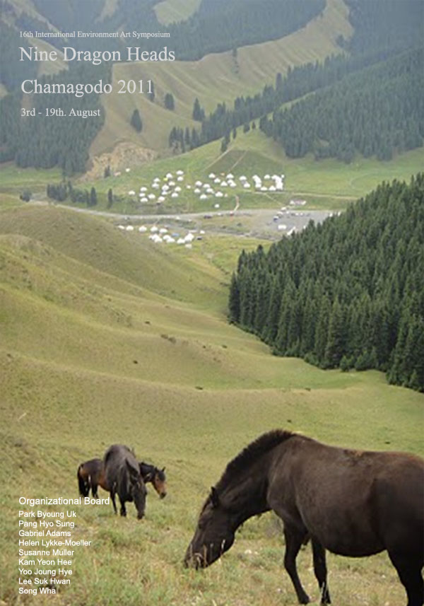
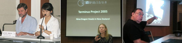
Nine Dragon Heads
|
|
|
|
Nine Dragon Heads makes an
attempt and stimulation to leave better heritage in the future from the environmental
and spiritual viewpoint. Human
beings have repeated evelopment with enormous domination and control about
environment. There is no doubt that
human beings are superior in every respect.
|
|
|
| Thinking back to the
past history, many species on the earth were exterminated because for some
reason the friendly environment which helped their birth changed into hostile
attitude. While
mankind, the first species that had the ability of operating on surroundings,
have got out of innumerable change of nature to some degree. |
| But human has regarded
the nature as the target of challenge and conquest, that is to say, as the
subject of testing mankind's ability in the process of transforming and
possessing the nature. |
|
|
|
Ultimately if we are asked a
question when the mankind will disappear, we may answer "the day will not
be far distant." No matter how peculiar men may be, we must deeply realize
that men are also the product of appropriate environment and the part of huge
nature.
|
|
|
|
Can men lead a life with
understanding and respect about the world of nature?
|
|
Can men maintain a
life peacefully and fairly for the long survival of mankind?
|
|
What decide this future of human is the mutual
relation between human and human, human and circumstances.
|
|
|
|
NINE DRAGON HEADS changes
close-minded 'I' into open-minded 'I' and urges to reconsider equilibrium
relation between human and environment through the art holding in common
human's infinite imagination, experience, and ideas.
|
|
|
| NINE DRAGON HEADS joins
various cultures and unfolds international composite art. We hope to have in common
community consciousness and impulsion of the cooperation existed deeply in
human's heart through these various forms. |
| Human beings who have
single species of Homo Sapiens Sapiens have developed wide and diverse culture.
We understand that the diverse difference of culture is the speciality of
culture itself, not comparison or superiority. |
|
|
|
NINE DRAGON HEADS expects to have a new understanding of human nature and
world through the art as long as men. We anticipate that we can leave healthier
environment-the heritage of future-to posterity through the curable function of
art.
|
|
|
|
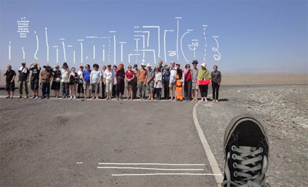
Open Air Symposium
|
|
|
|
Period: 3rd ~19th. August
|
|
Venue : Yunnan – Tibet - Nepal
|
|
|
|
Responsible for
their own art works
(Video, Drawing, Installation,Performance...etc) and can
choose the working area freely during on journey ( 3rd~19th. August ). Artist
might works impromptu at the Trail
Trip because In the circumstances it would be difficult to find enough time to
prepare work
|
|
|
|
Selecting List
|
|
Bernhard
Gerber(CH), Charlotte Parallel (NZ). Christophe Doucet(FR), Daniela de
Maddalena(CH), Denizhan
Ozer(TK), Felix
Pedersen (DK), Fredi Luedi
(CH), Gabriel Adams (USA) , Helen
Lykke-Moeller (DK), Henrik
Broch-Lips (DK), Kam Yeon Hee
(KR), Kelli Sharp (AU), Lee
Byeong Wook & OULIM (KR), Pang Hyo Sung (KR), Park Byoung Uk (KR), Steen
Rasmussen (DK), Susanne Muller (CH). Yoko Kajio (JP/AU), Yoo
Joung Hye (KR),
|
|
|
|
|
|
|
Conference
|
Period: 17th. August
|
|
Venue : National Museum ( Kathmandu. NEPAL )
|
|

|
Presentation on Topic of
Nomadic Party 2
|
Available
Equipmet : Internet
WIBRO . Beam Projector
|
|
|
|
Document Show & Artist Talk
|
Period: 3rd, Sept
|
|
Venue : ARKO Artist House ( Seoul, KOREA )
|
|
|
|
Artists to
make Document Show & Presentations
on their work (approx 10mins
each) and free talk
|
Available Equipmet : Internet WIBRO . Beam
Projector
|
|
|
|
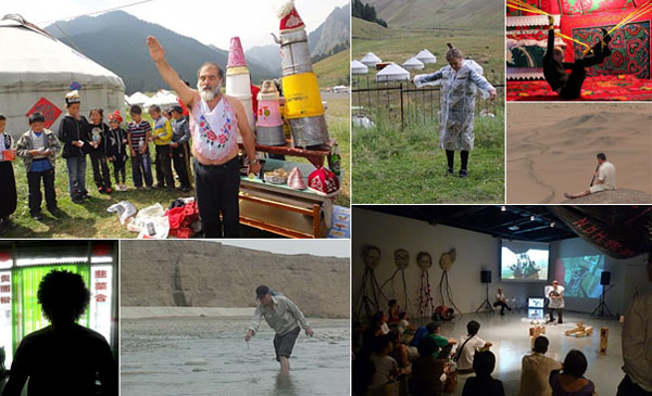
Performance
|
Period: 4th ~ 18th . August
|
Venue : Druing the Tirp / Nepal National Museum
|
|
|
|
Main Sites Along The Route
|
|
|
|
|
|
Ancient Tea-Horse
Road
|
|
|
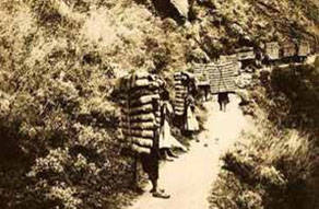
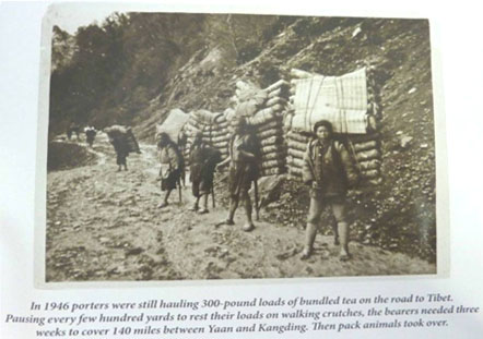
| For thousands of years, there was an ancient
road treaded by human feet and horse hoofs in the mountains of Southwest China, bridging the Chinese hinterland and the
Qinghai-Tibet Plateau. Along the unpaved and often rugged road, tea, salt and
sugar flowed into Tibet,
while horses, cows, furs, musk and other local products came out. The ancient
commercial passage, dubbed the "Ancient
Tea-Horse Road", first appeared during the
Tang Dynasty (618-907), and lasted until the 1960s when Tibetan highways were
constructed. Meanwhile, the road also promoted exchanges in culture, religion
and ethnic migration, resembling the refulgence of the Silk
Road. |
| The road stretched across more than 4,000 kilometers mainly in Southwest
China's Sichuan and Yunnan provinces and the Tibetan Autonomous
Region. Just as the Silk Road, the Ancient
Tea-Horse Road disappeared with the dawn of modern
civilization, but both routes have played very important roles in the
development of China.
Different Chinese ethnic cultures, such as the Dai, Yi, Han, Bai, Naxi and
Tibetans, have met, fused and developed along the historic road. |
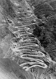
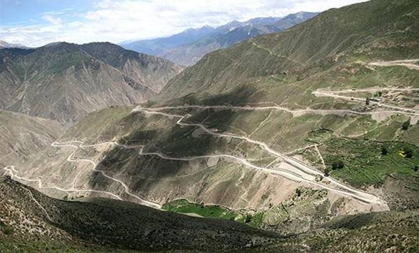
| The road ran across the Hengduan
Mountains and the
Qinghai-Tibet Plateau -- an area of the most complicated geological conditions
and most diversified organisms. Besides its cultural and historic value, the
road was also highly appreciated by adventurers and scientists. |
|
|
| Tea and horses blazed the
way |
|
|
|
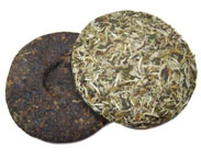
P u-erh tea is highly esteemed both in taste and color, it was named after
its producing area -- Pu-erh County
in Yunnan Province, which is one of the cradles of China's
"tea culture". During the Tang Dynasty, Pu-erh tea was grown in areas
flanking the Lancang
River. It was described
as having a bitter taste at first, then sweet.Inorder to preserve Pu-erh tea and to facilitate its trade with merchants
travelling the Ancient Tea-Horse Road, a method was developed which led to the
steaming of Pu-erh Tea and then compressing it into various shapes - usually a
type of bowl shape or a "brick". This type of tea is known as Tuocha
Tea. The word Tuocha sometimes spelled "Tuo Cha", or "Tuo
Tea", the meaning is block of tea. Tuocha Tea can also be known by
different names such as "beeng cha" (or "bing cha" or
"ping cha"), and "fang cha". These names simply refer to
the type of shape into which the Tuocha Tea is pressed - eg bing cha is
"biscuit shaped" and fang cha is "square shaped".
|
|
|
|
During the World War II, when Myanmar
fell into the hands of the Japanese, the Yunnan-Myanmar Highway -- then China's only
international thoroughfare -- was cut off. The Ancient
Tea-Horse Road, extending from Lijiang in Yunnan, to Kangding in Xikang, and then to Tibet and even further into India, was
revived and became a major trade route. With the opening of the Yunnan-Tibetan
and Sichuan-Tibetan highways in the 1960s, the road declined. Some sections of
the famous road, however, are still used for transport purposes. Today, the
road comes to the fore again with the development of tourism in Yunnan and Sichuan
provinces, as well as in the Tibetan Autonomous Region.
The road passes through subtropical forests and picturesque lakes and
turbulent rivers, such as Lancang, Nujiang, Minjiang and Yarlung Zangbo.
Heading west from the Hengduan
Mountains, one has to
cross many peaks -- each towering 4,000-5,000 meters above sea level. But tea
and horses have blazed a trail despite the challenges posed by mountains and
forests. Roads devoted to the tea-horse trade linked ethnic groups living in
areas near the roads, making them members of the great Chinese nation.
|
|
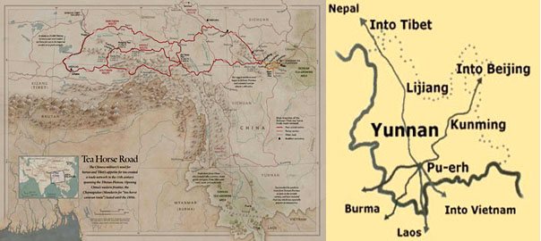
Six major routes
|
|
|
|
Chinese expert researching the Ancient Tea-Horse Road recently found a
complete map of the road drawn more than 150 years ago by a French missionary.
The map reveals that the road traversed a series of towering mountains, with
rivers flowing in between from south to the north. Roughly speaking, there were
6 main routes:
|
Route One:
Begins in Xishuangbanna and Simao, home of Pu-erh tea via Kunming
to other Province in China
into Beijing.
|
Route Two:
Begins in Pu-erh (via Simao, Jinhong, Menghai to Daluo) in Yunnan Province
into Burma, then from Burma into Thailand,
Singapore, Malaysia and
Hongkong.
|
Route Three:
Begins in Pu-erh via Lijiang, TigerLeaping
Gorge into
Tibet, then from Lhasa into Nepal
and India.
|
Route Four:
Begins in Pu-erh via Jiangcheng in Yunnan into
Vietman, then from Vietman into Tibet
and Europe.
|
Route Five:
Begins in Pu-erh via Simao, Lanchang, Menglian in Yunnan
into Burma.
|
Route Six:
Begins in Pu-erh via Mengla in Yunnan into Burma. Tens of
thousands of traveling horses and yaks created a definite path with their hoofs
on the once-indiscernible road. Today, although even such traces of the ancient
road are fading away, its cultural and historic values remain.
|
|
Nine Dragon HeadsTrip Overview
|
|
Route 3 : Lijiang -TigerLeaping Gorge –Shangrila –Yanjing
–Lhasa –Himalaya base camp—Kathmandu
|
|
|
|
Beginning in the 10th
century AD, a vibrant trade route linked China,
India and Burma, crossing
a landscape as diverse as the traders who followed it. As these traders stopped
at outposts along their route, they exchanged not only commercial goods, but
also cultural traditions. In southwest China’s
Yunnan province, this route, which was called
the Tea and Horse Caravan Trail, transported blocks of tea from Sichuan and Yunnan to
trade for horses bred in Tibet.
Traces of Tibetan, Indian and Burmese cultural influences can still be found in
this area. On this journey, we retrace a portion of the fabled Ancient Tea
& Horse Caravan Trail, which, though no longer in use, still retains many
of its historical remnants, villages and local ethnic minority communities.
Incorporating parts of our classic Yunnan
trip, South of the Clouds, this journey immerses travelers in the
rural areas of the Caravan Trail. we pass through rolling hills and pine
forests, visiting mythic 1,200-year-old grottoes, which trace back to the very
beginnings of Buddhism in China,
and an ancient trading post. We also follow the same paths used by 10th
century merchants to a former salt mine and key stop for the caravans, all the
while dining and staying with local Bai ethnic minority villagers.
|
|
|
Yunnan
|
|
Yunnan—which
literally means “South of the Clouds” due to its location just south of the
lofty Tibet-Qinghai Plateau—is home to some of the most diverse cultures,
ecology, and terrain in China. With verdant low-lying valleys, spectacular white-capped
mountains, rustic towns and villages, and a lively mix of ethnic minority
communities, Yunnan
has long inspired poets and travelers. On
this journey, explore Yunnan’s
diversity and classic sights, including the UNESCO World Heritage Site of Lijiang.
Navigate through villages and meet Bai, Naxi, and Tibetan ethnic minority
communities. We visit an ancient trading post along the Tea & Horse Caravan Trail; explore
the region's botanic and geological wonders at Jade Dragon Snow Mountain;
and conclude in Shangri-La, where we witness the fascinating and deeply
spiritual Tibetan world.
|
|
|
|
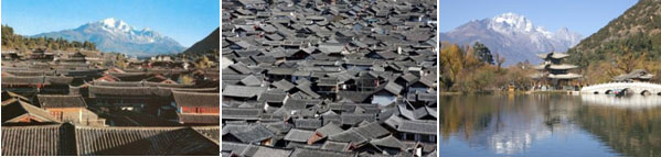
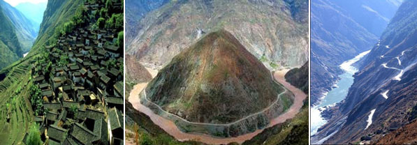
Lijiang The world famous Old Town of Lijiang is located in Lijiang City.
It is a UNESCO Heritage Site. The town has a history
going back more than 800 years and was once a confluence for trade along the
old tea horse road. The Lijiang old town is famous for its orderly system of
waterways and bridges. The old town of Lijiang differs from other ancient
Chinese cities in architecture, history and the culture of its traditional
residents the Nakhi people, therefore people there are called pàng jīn gē, pàng
jīn mèi, male and female respectively.
|
|
|
|
Tiger Leaping
Gorge is
a canyon on the Yangtze
River – locally called the Golden Sands River – located 60 km
north of Lijiang City, Yunnan in southwestern China. It is part of the Three Parallel Rivers of Yunnan Protected Areas World Heritage Site. Around
15 km in length, the gorge is located where the river passes
between 5,596 metre Jade Dragon Snow Mountain and
5,396 m Haba
Xueshan in a series of rapids under steep 2000 metre cliffs. Legend says that in
order to escape from a hunter, a tiger jumped across the river at the
narrowest point (still 25 metres wide), hence the name. Administratively, the
river in this area forms the border between Yulong Naxi Autonomous County of Lijiang City and Shangri-La
County of Diqing Tibetan Autonomous Prefecture.
|
|
|
|
Tiger Leaping
Gorge is a contender for the world's deepest river canyon, depending on the
exact definition used. The inhabitants of the gorge are primarily the
indigenous Naxi people, who live in a
handful of small hamlets.
|
|
|
|
Tibet
|
Tibet (Tibetan) is a plateau
region in Asia, north of the Himalayas. It is home to the
indigenous Tibetan people, and to some other ethnic
groups such as Monpas and Lhobas, and is inhabited by considerable
numbers of Han and Hui people. Tibet is the
highest region on earth, with an average elevation of 4,900 metres
(16,000 ft). It is sometimes referred to as the roof of the world . During Tibet's
history, starting from the 7th century, it has existed as a unified empire and
as a region of separate self-governing territories, vassal states, and Chinese provinces. In
the interregnums, various sects of Tibetan Buddhism, secular nobles, and
foreign rulers have vied for power in Tibet. The latest religious
struggle marked the ascendancy of the Dalai Lamas to power in western Tibet in the
17th century, though his rule was often merely nominal with real power resting
in the hands of various regents and viceroys. Today, most of cultural Tibet is ruled as autonomous areas in the People's Republic of China.
|
|
|
|
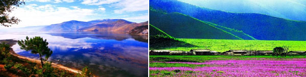
Shangri-La is a primarily Tibetan county in northwestern Yunnan Province in southwest China and the capital of Diqing Tibetan Autonomous Prefecture The county was formerly called Zhongdian
County (Chinese: Zhōngdiàn Xiàn) but was renamed in 2001 after the
fictional land of Shangri-La in the 1933 James
Hilton novel Lost
Horizon, in an effort to promote tourism in the area. The local
Tibetan population refers to it by the name Gyalthang (Tibetan) . "Shangri-La"
or "Zhongdian" may also refer to Jiantang Town
(Jiàntáng Zhèn), the capital of the county
|
|
|
|
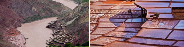
Yan Jing The Salt Well and Salt
Fields in the Himalaya - The Mekong River Valley -
|
|
The village of Yanjing was
the first stop on the ancient Tea Leaf Trail from Southwest Yunnan to Lhasa.
|
The population of the area is mostly Naxi, a tribe with an
assimilated Tibetan lifestyle but old individual traditons and rites. In a narrow upstream valley of the Mekong / Lancang River, there is a well deep into the
earth, right beside the river, where salt water can be scooped out. The water
is carried to a set of man-made platforms, like rice terrace fields, spread out
to dry in the wind and sunshine and the salt is then used as merchandise in the
barter trade along the narrow valleys of this Himalaya Area, all the way toward
Lhasa. The use of horses from Tibet,
the only way of transporting commodities locally, ads to the attractiveness of
the rugged scenery.
|
After the rainy season, the platforms nearest to the river are
usually destroyed by the flood waters and have to be rebuilt. The well has a
high wall around to protect it from the floodwaters of the river. Its salty
content is proof of the emergence of Himalaya Mountains
from the seabed many many many thousand years ago.
The hard labour of the salt fields is carried out by the womanfolk, since the
men are mostly out in the trading caravans. One woman is married to all the
brothers of a family. The woman's work of carrying the water and salt packages
is very hard. Sometimes they even collect salt from "icicles" that
form below the platforms. This is the most purest salt they have and used for
religious ceremonies. Yet these people are very very poor and some can not even
afford special cloths for their own wedding ceremony.
|
|
|
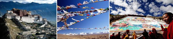
Lhasa is the administrative capital of
the Tibet Autonomous Region
in the People's Republic of China
and the second most populous city on the Tibetan
Plateau, after Xining.
At an altitude of 3,490 metres (11,450 ft), Lhasa is one of the highest
cities in the world. It contains many culturally significant Tibetan Buddhist sites
such as the Jokhang, Potala
and Norbulingka palaces. Lhasa is part of a
township-level prefecture, the Lhasa
Prefecture, consisting of 7 small counties: Lhünzhub County, Damxung County, Nyêmo County, Qüxü County, Doilungdêqên County, Dagzê County and Maizhokunggar County. Lhasa
literally means "place of the gods", although ancient Tibetan documents
and inscriptions demonstrate that the place was called Rasa, which
means "goat's place", until the early 7th centry
|
|
|
Nepal
|
|
|
Nepal officially the Federal Democratic Republic
of Nepal, is a landlocked country in South Asia.
It is located in the Himalayas
and bordered to the north by the People's Republic of China,
and to the south, east, and west by
|
the Republic of India.
With an area of 147,181 square kilometres (56,827 sq mi) and a
population of approximately 30 million, Nepal is the world's 93rd largest
country by land mass[ and the 41st most populous country. Kathmandu
is the nation's capital and the country's largest metropolis. Nepal has a rich
geography. The mountainous north has eight of the world's ten tallest
mountains, including the highest point on Earth, Mount
Everest, called Sagarmatha in Nepali. It contains
more than 240 peaks over 20,000 ft (6,096 m) above sea level. The fertile
and humid south is heavily urbanized. By
some measures, Hinduism
is practised by a larger majority of people in Nepal than in any other nation.
Buddhism, though a minority faith in the
country, is linked historically with Nepal as the birthplace of the Buddha. There
are 3 different buddhist traditions: Himalayan Buddhism, Buddhism of Kathmandu
Valley (mostly Mahayana
and Vajrayana), and also the Theravada
Buddhism.
|
|
|
|
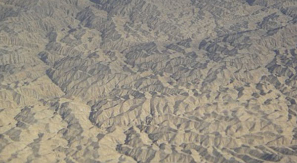
Himalaya Range (Sanskrit: literally, "abode
of snow", Hindi/Sanskrit ) the Himalayas or Himalaya for
short, is a mountain range in Asia, separating the Indian
subcontinent from the Tibetan Plateau. By extension, it is also
the name of a massive mountain system that includes the Karakoram, the Hindu Kush, and other, lesser,
ranges that extend out from the Pamir Knot. Together, the Himalayan
mountain system is the planet's highest, and home to the world's highest peaks,
the Eight-thousanders, which include Mount
Everest and K2. To comprehend the
enormous scale of this mountain range, consider that Aconcagua, in the Andes, at 6,962 metres
(22,841 ft) is the highest peak outside Asia, whereas the Himalayan system
includes over 100 mountains exceeding 7,200 m (23,622 ft) Some of the
world's major rivers, the Ganges, Indus, Brahmaputra, Yangtze, Mekong, Salween, Red River (Asia), Xunjiang, Chao Phraya, Irrawaddy River, Amu Darya, Syr Darya, Tarim River and Yellow
River, rise in the Himalayas, and their combined drainage basin is home to some 3 billion
people (almost half of Earth's population) in Afghanistan, Bangladesh, Bhutan, People's Republic of China, India, Nepal, Burma, Cambodia, Tajikistan, Uzbekistan, Turkmenistan, Kazakhstan, Kyrgyzstan, Thailand, Laos, Vietnam, Malaysia and Pakistan.
|
|
|
|
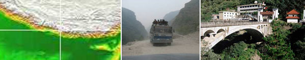
Kodari, The town of Kodari lies on the
Nepal-China border. Besides being a place of interesting and unique natural
beauty, it has an important historical background tracing back to ancient
times. For those who are planning to travel from Nepal
to China
(or vice versa) by heading through Kodari, you will become a part of history. Kodari
was originally a base point for the trans-Himalayan caravan route or what some
people describe as the Nepali version of the Silk Road.
Merchants who were bound for Lhasa would have to pass through here then would
proceed to head north from Kodari and cross the Kuti pass before turning east
to begin the perilous journey over the Tibetan plateau. Today, this border
village is still an important trading center between China
(Tibet) and Nepal. The 144
kilometer Arniko Highway
connecting Kathmandu with Kodari
is not just a useful path but it is also very beautiful. The route passes
through magnificent river gorges and splendid mountain scenery.
Three kilometers short of Kodari is one of the famous hot water springs called
Tatopani (tato= hot and pani=water). People travel here from all over Nepal to rest
their tired bodies in the hot water for its therapeutic value and also for the
relaxing atmosphere.
|
|
|
|
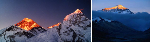
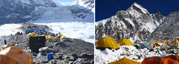
Himalaya Base
Camp - one
of the most beautiful places in the world – the small town of Tingry
–where we got a first good look at the highest mountain range in the world, and
got to see the brightest stars ever.
|
|
|
There are two major way to start the Expedition, the one way,
you must fly to beautiful & traditional city Lhasa & another way you
must drive from KTM via Zangmu/Nylam, tingry & base camp(5200m). The visit
to Lhasa, the
overland journey across the Tibetan Plateau, the trek in the footsteps of
Mallory and a climb with awesome views of Everest, are the ingredients of a
very special expedition. It will also give a life-long impression of Tibet and its
people and an insight and deep respect for the achievements of the early
Everest pioneers.
|
|
|
|
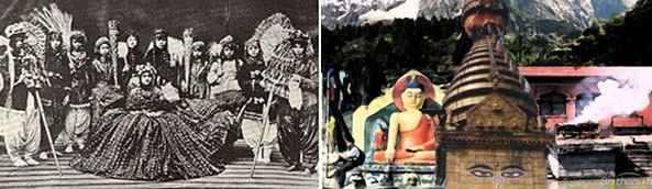
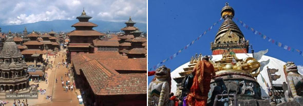
Kathmandu is
the capital and
largest metropolitan city of Nepal. The city is the urban core of the Kathmandu
Valley in the Himalayas, which also contains
two sister cities namely Patan or Lalitpur, 5 kilometres (3.1 mi) to its southeast (an ancient city of fine
arts and crafts) and Bhaktapur, 14 kilometres (8.7 mi) to its east (city of devotees).Kathmandu
is not only the capital of the Federal Democratic Republic of Nepal but also
the headquarters of the Central Region (Madhyamanchal) among the five
development regions constituted by the 14 administrative zones of Nepal located
at the central part of the country. The Central region has three zones namely, Bagmati, Narayani and Janakpur. Kathmandu is located in the Bagmati Zone.
|
|
|
The city’s rich history is nearly 2000 years old, as inferred from an
inscription in the valley. Its religious affiliations are dominantly Hindu followed by Buddhism. People of other religious beliefs also live in Kathmandu
giving it a cosmopolitan culture. Kathmandu is now the premier cultural and
economic hub of Nepal and is
considered to have the most advanced infrastructure among urban areas in Nepal. From the point of view of tourism, economy and cultural heritage,
the sister cities of Patan(lalitpur) and Bhaktapur are integral to Kathmandu. Even the
cultural heritage recognition under the World Heritage list of the UNESCO has recognized all the monuments in the three urban agglomerates as
one unit under the title “Kathmandu
Valley-UNESCO World Heritage Site.
|
|
|
|
Details Schedules
|
|
|
|
August
|
2nd
~3rd
|
Arrival on Kunming Airport (Yunnan. China)
Guide meeting / Hotel Room Arragement -
Fu Sheng Garden
Hotel www.fshyhotel.com
|
|
|
|
|
4th
|
09:00~ Check Out
11:00~ Flight to Jijiang …by China Airline
12:00~ Arrival Jijiang ( Hotel-Room
arrangement )
14:00~ Survey to Ancient Castle, Jade
Dragon Mountains,
|
|
|
|
|
5th
|
09:00~ Chech Out / Go to Tiger Leaping
Gorge-….by BUS
12:00~
Arrival “Sang-Kyodujin” ( Front of Tiger Leaping
Gorge )
15:00~
Survey ( 2 Hours )
17:00~ Hotel Room Arragement
|
|
|
|
|
6th
|
09:00~ Check Out / Go to Shangri-la….by BUS
11:00~
Survey to Ancient Castle & Visit
JangJok Village….by
Horse Ridding
15:00~ Go to Deqin …by BUS / Sun Set at Meri Snow
Mountain
17:00~ Hotel Room Arrangement
|
|
|
|
|
7th
|
07:00~ Breakfast with Sun-Rise at
Meri Snow Montain
09:00~ Cheak Out / Go to Yan Jing
..by Jeep
12:00~ Arrival at Yan Jing ( Solt Farm)
15:00~ Survey ( 2 Hours )
17:00~ Hot Spring ( Room Arrangement)
|
|
|
|
|
8th
|
09:00~ Check Out
10:00~ Survey ( 2 Hours ) Solt Farm
14:00~ Go to Mangkang – ..by Jeep
17:00~ Arrival Zogang / Hotel ( Room Arrangement)
|
|
|
|
|
9th
|
09:00~ Check Out
Zogang- Basu- Rawu…..by Jeep
17:00~ Arrival at Rawu Lake
( Wacheon Village- Hotel Room Arrangement )
|
|
|
|
|
10th
|
09:00~ Check
Out / Go to Poumi -..by Jeep
10:00~ Survey ( 2 Hours )
17:00~ Arrival Peijin / Hotel Room Arrangement
|
|
|
|
|
11th
|
09:00~ Check
Out
10:00~ Go to Lhasa
..by Jeep
14:00~ Survey ( 2 Hours )
17:00~ Arrival Lhasa
/ Hotel Room Arrangement
|
|
|
|
|
12th
|
09:00~ Survey
Potala Palace,
Jo Kang Temple, Sera
Temple....Market etc
|
|
|
|
|
13th
|
09:00~ Check
Out
10:00~ Go to Shigatse
by Jeep
11:00~ Survey to Temple , Lake.
17:00~ Arrival Shigatse / Hotel Room Arrangement
|
|
|
|
|
14th
|
09:00~ Check
Out
10:00~ Go to Tingri …by Jeep
11:00~ Survey to Temple,
Market.
17:00~ Arrival Tingri / Hotel Room Arrangement
|
|
|
|
|
15th
|
09:00~ Check
Out / Go to Himalaya Base Camp …by Jeep
15:00~ Treking ( 1 Hour )
17:00~ Back to Tingri
|
|
|
|
|
16th
|
09:00~ Check
out / Go to Kodari ( border ) ….by
Jeep .
13:00~ Room Arrangement
Relax ( Equarizing for Altitude )
|
|
|
|
|
17th
|
08:00~ Check
Out / Go to Kathmandu
…By BUS
12:00~ Arrival at Kathmandu
/ Hotel Room Arrangement.
07:00~ Survey to Palaces, Temples, Market ..etc
|
|
|
|
|
18th
|
09:00~ Set Up
18:00~ Conference
(at National Musem. Napal )
22:00~ Farewell Party
|
|
|
|
|
19th
|
Individual Departure
|
|
|
Video Link :
|
http://www.youtube.com/watch?v=WSveCk7ZPmA
|
http://www.youtube.com/watch?v=Rgc0TF0aj_M
|
http://www.youtube.com/watch?v=Y7LcYhJ9G8c
|
http://www.youtube.com/watch?v=MoothAtha5g
|
http://www.tagstory.com/video/video_post.aspx?media_id=V000166964
|
|
|
|
|