Nine Dragon Heads makes an attempt and stimulation to leave better heritage in the future from the environmental and spiritual viewpoint. Human beings have repeated development with enormous domination and control about environment. There is no doubt that human beings are superior in every respect.
Thinking back to the past history, many species on the earth were exterminated because for some reason the friendly environment which helped their birth changed into hostile attitude. While mankind, the first species that had the ability of operating on surroundings, have got out of innumerable change of nature to some degree. But human has regarded the nature as the target of challenge and conquest, that is to say, as the subject of testing mankind's ability in the process of transforming and possessing the nature.
Ultimately if we are asked a question when the mankind will disappear, we may answer "the day will not be far distant." No matter how peculiar men may be, we must deeply realize that men are also the product of appropriate environment and the part of huge nature.
Can men lead a life with understanding and respect about the world of nature ? Can men maintain a life peacefully and fairly for the long survival of mankind ? What decide this future of human is the mutual relation between human and human, human and circumstances.
NINE DRAGON HEADS changes close-minded 'I' into open-minded 'I' and urges to reconsider equilibrium relation between human and environment through the art holding in common human's infinite imagination, experience, and ideas. NINE DRAGON HEADS joins various culture and unfolds international composite art. We hope to have in common community consciousness and impulsion of the cooperation existed deeply in human's heart through these various forms. Human beings who have single species of Homo Sapiens Sapiens have developed wide and diverse culture. we understand that the diverse difference of culture is the speciality of culture itself, not comparison or superiority.
NINE DRAGON HEADS expects to have a new understanding of human nature and world through the art as long as men. We anticipate that we can leave healthier environment-the heritage of future-to posterity through the curable function of art.
Open Air Symposium
Period: 20th.September~7th. October
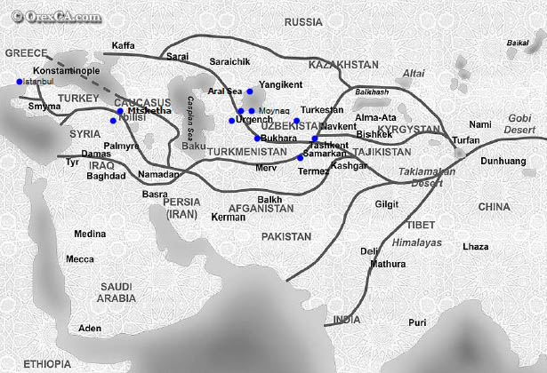
Venue : Tashkent –Smarkand –Bukhara –Ayaz Kala- Khiva –Kizilkum Desert--Nukus--Aral Sea(Moynaq) –Tbilisi
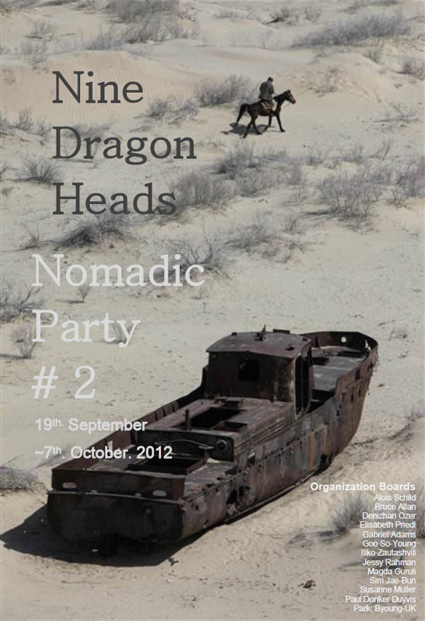
Coordinator: Alois Schild, Gabriel Adams, Park Byoung-Uk, Sim Jae-Bun
Participants
Ali Bramwell(NZ/IR), Alois Schild(AT), Annelise Zwez(CH), Bernhard Gerber(CH), Bruce Allan(UK), Bram Arnold Thomas(UK), Channa Boon(NL), Christophe Doucet(FR), Daniela de Maddalena(CH), Denizhan Ozer(TK), Elisabeth Peridl(AT), Enrique Muñoz Garcia(CL), Fred Luedi(CH), Gabriel Adams(USA), Graham Richard(NZ), Harold de Bree(NL), Jessy Rahman(SR),Juliet Fowler(AU), Lisa Benson(NZ), Marjolijn van de meij(NL), Max Buehlman(CH), Park Byounguk(KR), Paul Donker Duyvis(NL), Sim Jae-Bun(KR), Susanne Muller(CH), Suzanne Bartos(AU), Yoko Kajio(JP/AU), Yoo Joung-Hye(KR),Art in Dialog : Henrick (DK), Studio Zero: Kelli & Lois (AU), FLUT: Harry & Rufus (BL)
Responsible for their own art works (Video, Drawing, Installation, Performance...etc) and can choose the working area freely during on journey. Artist might works impromptu at the Trail Trip because In the circumstances it would be difficult to find enough time to prepare work
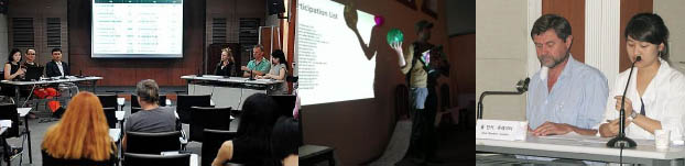
Conference
Date/Time : 19th. Spetember. 11:00~13:00
Venue : Istanbul Modern (Turkey)
Coordinator: Denizhan Ozer
Panel : Annelise Zwez, Elisabeth Priedl, Gabriel Adams, Suzanne Bartos, Yoko Kajio. Park Byoung-Uk
Opened to anybody invited to the Nine Dragon Heads 2012 Nomadic Party who wishes to participate.
Outdoor Exhibition – Presentation 'Boat to boat'
Period : 29th. September 13:00 ~16:00 ( 3 Hours )
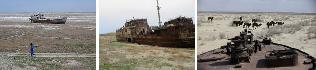
Venue : Graveyard of Ship – Moynaq / Aral Sea
Coordinator : Park Byoung Uk, Gabriel Adams
Participation : Artists responsible for bringing own art work ( Installation, Drawing, Video, Performance ..etc)
and setting up directly in Shipwreck. Artist can choose the working area freely.
Indoor Exhibition
Period : 5th~15th. October
Set Up : 1st ~5th.
Opening : 5th. 18:00
Venue : 'Karvasla' National Museum (Tbilisi. Georgia)
Coordinator : Iliko Zautashvili, Magda Guruli, Paul Donker Duyvis
Participation : Artists responsible for bringing suitable work ( Installation, Objects, Video ..etc) and setting up
their own works, also you can make an art work or installation directly in exhibition hall during period
Presentation - Screening . Round Table on Topic
Date/Time : 6th. October. 11:00~13:00
Venue : 'Karvasla' National Museum (Tbilisi. Georgia)
Coordinator: Bruce Allan. Elisabeth Preidl
Participation : Artists to make presentations on their work (approx 10mins each) and free talk
Opened to anybody invited to the Nine Dragon Heads 2012 Nomadic Party who wishes to participate
Performance
Period : 21th. September ~ 5th. October
Venue : During the Tirp / Karvasla National Museum
Coordinator : Jessy Rahman, Susanne Muller
Main Sites Along The Route 2012
Nine Dragon HeadsTrip Overview
Tashkent-- Samarkand-- Bukhara-- AyazKala-- Urgench/Khiba-- Nukus-- Moynaq-- Aral Sea-- Kyzil Kum Desert-- Tbilisi
Great Silk Road and its influance on Central Asia's history
The famous Great Silk Road ran through Central Asia, making it a very significant and important region in terms of human evolution, cultural exchange, trade and commerce. It was also vital for the exchange of knowledge, philosophy, religion and ideas. The Silk Road was basically a great crossroads between Europe, southern Asia, western Asia and East Asia. Unfortunately, this vital and strategic geographical situation also made the area a prime target for invading empires. Many savage and historic battles were fought throughout the centuries in Central Asia. Time and time again the people were subjugated and their legacy smashed and shattered, yet inevitably they would rise again, somehow managing to preserve the very unique nature of the culture of Central Asia. One result of this series of invasions is the creation of an extremely diverse population. Central Asia is an exciting blend of many cultures, with a strong undercurrent of Central Asian integrity. Among the mixed population the tourist to Central Asia will find influences of India, China, Russia, Pakistan, and Persia. The influence of the eclectic culture is seen in the unique art, architecture, theatre and music of Central Asia
History of conquests. Influence of climate and geography on the history of region.
The climate and geography of Central Asia has played a defining role in its history. The arid weather across much of the region was not conducive to agriculture, while its distance from the sea kept it isolated from much trade, which was mainly carried out through natural sea ports. Consequently, few major cities developed in Central Asia, and for millennia it was dominated by the nomads of the steppe regions, who were very accomplished horseback riders. The lifestyle of the nomadic horse people was well suited to warfare, and the steppe terrain allowed for rapid mobility. Thus they became very militarily potent. Once they finally became internally unified, they became a nearly unstoppable power. Internal unification was most likely achieved because of the influence of the Great Silk Road, which ran through Central Asia. Occasionally, great leaders would manage to organize several nomadic tribes into one mighty force. This is how the Hun invasion of Europe was organized, and the great Mongol conquest of most of Eurasia. From this period came such mighty conquerors as Alexander the Great, Genghis Khan and Attila the Hun.
Tashikent In pre-Islamic and early Islamic times the town and the province were known as "Chach". The Shahnameh of Ferdowsi also refers to the city as Chach. Later the town came to be known as Chachkand/Chashkand, meaning "Chach City".(Tash in Turkic languages means stone. Kand, qand, kent, kad, kath, kud—all meaning a city—are derived from the Persian/Sogdian kanda, meaning a town or a city. They are found in city names like Samarkand, Yarkand, Penjikent, Khujand etc.). After the 16th century, the name was steadily changed slightly from Chachkand/Chashkand to Tashkand, which, as "stone city", was more meaningful to the new inhabitants than the old name. The modern spelling of Tashkent reflects Russian orthography.Tashkent started as an oasis on the Chirchik River, near the foothills of the West Tian Shan Mountains. In ancient times, this area contained Beitian, probably the summer "capital" of the Kangju confederacy. The principality of Chach, whose main town had a square citadel built around the 5th to 3rd centuries BC, some 8 kilometres south of the Syr Darya River. By the 7th century AD, Chach had over 30 towns and a network of over 50 canals, forming a trade center between the Sogdians and Turkic nomads. The region came under the sway of Islam in the early parts of the 8th century.
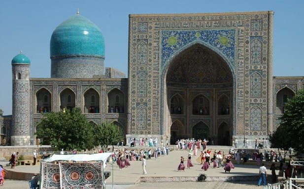
Samarkand is one of the oldest inhabited cities in the world, prospering from its location on the trade route between China and the Mediterranean (Silk Road). At times Samarkand has been one of the greatest cities of Central. Founded circa 700 BC by the Sogdians, Samarkand has been one of the main centres of Iranian civilization from its early days. It was already the capital of the Sogdian satrapy under the Achaemenid dynasty of Persia when Alexander the Great conquered it in 329 BC. The Greeks referred to Samarkand as Maracanda.[ The city is most noted for its central position on the Silk Road between China and the West, and for being an Islamic centre for scholarly study. In the 14th century it became the capital of the empire of Timur. The Bibi-Khanym Mosque remains one of the city's most notable landmarks. The Registan was the ancient center of the city. In 2001, UNESCO added the city to its World Heritage List as Samarkand – Crossroads of Cultures.
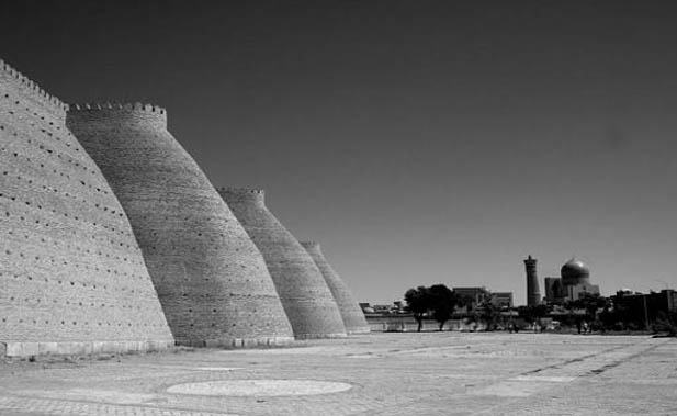
Bukhara The history of Bukhara stretches back millennia. It is now the capital of the Bukhara Province (viloyat) of Uzbekistan. Located on the Silk Road, the city has long been a center of trade, scholarship, culture, and religion. During the golden age of the Samanids, Bukhara became the intellectual center of the Islamic world and therefore, at that time, of the world itself. The historic center of Bukhara, which contains numerous mosques and madrassas, has been listed by UNESCO as one of the World Heritage Sites.
Bukhara has been one of the main centres of Persian civilization from its early days in 6th century BCE. From the 6th century CE, Turkic speakers gradually moved in. Its architecture and archaeological sites form one of the pillars of Central Asian history and art. The region of Bukhara was for a long period a part of the Persian Empire. The origin of its inhabitants goes back to the period of Aryan immigration into the region.
Khiva In the early part of its history, the inhabitants of the area were from Iranian stock and spoke an Eastern Iranian language called Khwarezmian. Subsequently the Iranic ruling class was replaced by Turks in the 10th century A.D, and the region gradually tuned into an area with a majority of Turkic speakers.
The city of Khiva was first recorded by Muslim travellers in the 10th century, although archaeologists assert that the city has existed since the 6th century. By the early 17th century, Khiva had become the capital of the Khanate of Khiva, ruled by a branch of the Astrakhans, a Genghisid dynasty.
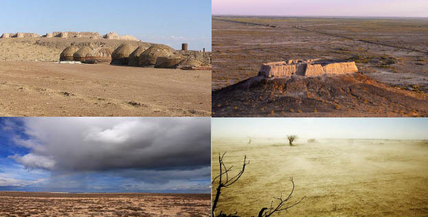
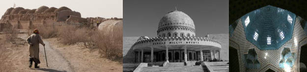
Ayaz Kala is an archaeological site in the autonomous republic of Karakalpakstan in Northern Uzbekistan. Ayaz Kala is located on the wastern side of the Sultan-Uiz-Dagh Mountains. The site consists of three fortresses which were built from the 4th cent. BC to the 7th cent. AD. The fortresses were part of a series of forts located at the edge of the Kizilkum Desert, which provided defence against raids by nomads and the Saca of the Syr-Darya delta. The W orld Monuments Fund has put Ayaz Kala on the watch list of 100 most endagered sites.
Kyzyl Kum Desert The Kyzyl Kum is the 11th largest desert in the world. Its name means Red Sand in Turkic languages. It is located in Central Asia in the doab between the rivers Amu Darya and Syr Darya, and is divided between Kazakhstan, Uzbekistan and (partly) Turkmenistan. It covers about 298,000 km²
The territory consists mainly of an extensive plain at an altitude up to 300 m above sea level, with a number of depressions and highlands (Sultanuizdag, Bukantau). Most of the area is covered with sand-dunes; in the North-West large areas are covered with takirs (clay coatings); there are also some oases. There are agricultural settlements along the rivers and in the oases. Temperatures can be very high during the summer months, from mid-May to mid-September. Kerki, one extreme inland city located on the banks of the Amu Darya River.
Nukus is the sixth-largest city in Uzbekistan, and the capital of the autonomous Karakalpakstan Republic.
It has a population of 260,000 (2004 estimate). The Amu Darya river passes west of the town.
The city is best known for its world-class Nukus Museum of Art.
History Nukus developed from a small settlement in 1932 into a large, modern Soviet city with broad avenues and big public buildings by the 1950s. The city's isolation made it host to the Red Army's Chemical Research Institute, a major research and testing center for Chemical Weapons.
Environmental concerns With the fall of the Soviet Union and the growing environmental disaster of the Aral Sea, the city's situation has deteriorated. Contamination of the region by wind-borne salt and pesticides from the dry Aral Sea bed have turned the surrounding area into a wasteland, with very high rates of respiratory disorders, cancer, birth defects and deformities.
Sights Nukus is host to the Nukus Museum of Art (also known as the State Art Museum of the Republic of Karakalpakstan, named after Igor V. Savitsky) and State Museum. The State Museum houses the usual collection of artifacts recovered from archaeological investigations, traditional jewelry, costumes and musical instruments, but more interestingly, displays of the area's now vanished or endangered flora and fauna, and on the Aral Sea issue. The Art Museum is noted for its collection of modern Russian and Uzbek art from 1918-1935. Stalin tried his best to eliminate all non Soviet art from this period, and sent most of the artists to the gulag. Both Savitsky himself and the collection at Nukus survived because of the city's remoteness. The documentary film The Desert of Forbidden Art is all about the collection and its history.
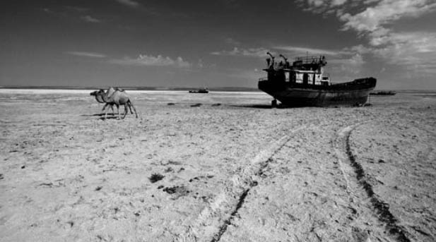
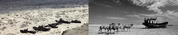
Moynaq Once a bustling fishing community and Uzbekistan's only port city with tens of thousands of residents, Mo‘ynoq is now a shadow of its former self, dozens of kilometers from the rapidly receding shoreline of the Aral Sea. Fishing had always been part of the economy of the region, and Mo‘ynoq became a center of industrial fishing and canning. However, overfishing the shallow sea in the past made it very susceptible to economic collapse as the Aral Sea has dried up. A regional agricultural monoculture dominated by cotton production which diverts water from tributary rivers of the sea into irrigation, and severe pollution caused by agricultural chemical runoff, are causing the sea to evaporate and the water that remains is highly saline and very toxic, causing the ecological disaster which is destroying the sea and killing the residents of the towns in its vicinity, including Mo‘ynoq.
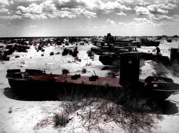

Aral Sea Formerly one of the four largest lakes in the world with an area of 68,000 square kilometres (26,300 sq mi), the Aral Sea has been steadily shrinking since the 1960s after the rivers that fed it were diverted by Soviet Union irrigation projects. By 2007 it had declined to 10% of its original size, splitting into four lakes – the North Aral Sea and the eastern and western basins of the once far larger South Aral Sea and one smaller lake between North and South Aral Sea.[3] By 2009, the south-eastern lake had disappeared and the south-western lake retreated to a thin strip at the extreme west of the former southern sea.[4] The maximum depth of the North Aral Sea is 42 m (138 ft) (as of 2008). The region's once prosperous fishing industry has been essentially destroyed, bringing unemployment and economic hardship. The Aral Sea region is also heavily polluted, with consequent serious public health problems. The retreat of the sea has reportedly also caused local climate change, with summers becoming hotter and drier, and winters colder and longer.
There is now an ongoing effort in Kazakhstan to save and replenish the North Aral Sea. As part of this effort, a dam project was completed in 2005; in 2008, the water level in this lake had risen by 24 m (79 ft) from its lowest level in 2007. Salinity has dropped, and fish are again found in sufficient numbers for some fishing to be viable. However, the outlook for the remnants of the South Aral Sea remains bleak. The shrinking of the Aral Sea has been called "one of the planet's worst environmental disasters".
In the early 1960s, the Soviet government decided that the two rivers that fed the Aral Sea, the Amu Darya in the south and the Syr Darya in the northeast, would be diverted to irrigate the desert, in order to attempt to grow rice, melons, cereals, and cotton. This was part of the Soviet plan for cotton, or "white gold", to become a major export. This eventually succeeded, and today Uzbekistan is one of the world's largest exporters of cotton. The construction of irrigation canals began on a large scale in the 1940s. Many of the canals were poorly built, allowing water to leak or evaporate. From the Qaraqum Canal, the largest in Central Asia, perhaps 30 to 75% of the water went to waste. Today only 12% of Uzbekistan's irrigation canal length is waterproofed. There are 47, 750 km of inter-farm irrigation channels in the basin, of which only 28% have anti-filtration linings. Only 77% of farm intakes have flow gauges, and of the 268, 500 km of on-farm channels, only 21% have anti-infiltration linings, which retain on average 15% more water than unlined channels.
By 1960, between 20 and 60 cubic kilometres (4.8 and 14 cu mi) of water were going each year to the land instead of the sea. Most of the sea's water supply had been diverted, and in the 1960s the Aral Sea began to shrink. From 1961 to 1970, the Aral's sea level fell at an average of 20 cm (7.9 in) a year; in the 1970s, the average rate nearly tripled to 50–60 centimetres (20–24 in) per year, and by the 1980s it continued to drop, now with a mean of 80–90 centimetres (31–35 in) each year. The rate of water usage for irrigation continued to increase: the amount of water taken from the rivers doubled between 1960 and 2000, and cotton production nearly doubled in the same period.
The disappearance of the lake was no surprise to the Soviets; they expected it to happen long before. As early as in 1964, Aleksandr Asarin at the Hydroproject Institute pointed out that the lake was doomed, explaining "It was part of the five-year plans, approved by the council of ministers and the Politburo. Nobody on a lower level would dare to say a word contradicting those plans, even if it was the fate of the Aral Sea.
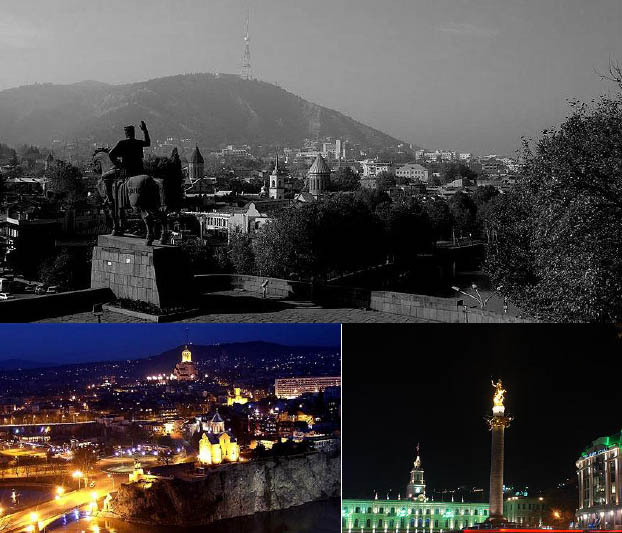
TBILISI Tbilisi is the capital and the largest city of Georgia, lying on the banks of the Mt'k'vari (Kura) River. The name is derived from an early Georgian form T'pilisi and it was officially known as Tiflis until 1936. The city covers an area of 726 km2 (280 sq mi) and has 1,480,000 inhabitants.
Founded in the 5th century by Vakhtang Gorgasali, the Georgian King of Iberia, and made into a capital in the 6th century, Tbilisi is a significant industrial, social, and cultural centre. The city is also emerging as an important transit route for global energy and trade projects. Located strategically at the crossroads between Europe and Asia and lying along the historic Silk Road routes, Tbilisi has often been a point of contention between various rival powers and empires. The history of the city can be seen by its architecture, where the Haussmannized Rustaveli Avenue and downtown are blended with the narrower streets of the medieval Narikala district.
Tbilisi is located in the South Caucasus at 41° 43' North Latitude and 44° 47' East Longitude. The city lies in Eastern Georgia on both banks of the Mt'k'vari River. The elevation of the city ranges from 380–770 meters above sea level (1246–1968 ft) and has the shape of an amphitheatre surrounded by mountains on three sides. To the north, Tbilisi is bounded by the Saguramo Range, to the east and south-east by the Iori Plain, to the south and west by various endings (sub-ranges) of the Trialeti Range.
The relief of Tbilisi is complex. The part of the city which lies on the left bank of the Mt'k'vari (Kura) River extends for more than 30 km (19 mi) from the Avchala District to River Lochini. The part of the city which lies on the right side of the Mt'k'vari River on the other hand is built along the foothills of the Trialeti Range, the slopes of which in many cases descend all the way to the edges of the river Mt'k'vari. The mountains, therefore, are a significant barrier to urban development on the right bank of the Mt'k'vari River. This type of a geographic environment creates pockets of very densely developed areas while other parts of the city are left undeveloped due to the complex topographic relief. To the north of the city, there is a large reservoir (commonly known as the Tbilisi Sea) fed by irrigation canals.
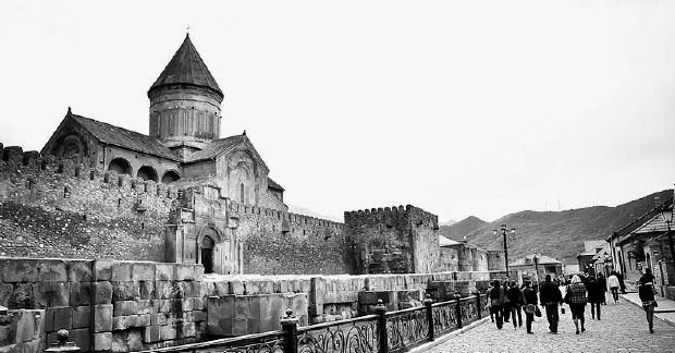
Mtskheta (Georgian: ![]() ), one of the oldest cities of the country of Georgia (in Kartli province of Eastern Georgia), is located approximately 20 kilometers north of Tbilisi at the confluence of the Aragvi and Kura rivers. The city (population 19,423 as of January 1, 2008) is now the administrative centre of the Mtskheta-Mtianeti region. Due to its historical significance and numerous ancient monuments, the "Historical Monuments of Mtskheta" became a UNESCO World Heritage Site in 1994
), one of the oldest cities of the country of Georgia (in Kartli province of Eastern Georgia), is located approximately 20 kilometers north of Tbilisi at the confluence of the Aragvi and Kura rivers. The city (population 19,423 as of January 1, 2008) is now the administrative centre of the Mtskheta-Mtianeti region. Due to its historical significance and numerous ancient monuments, the "Historical Monuments of Mtskheta" became a UNESCO World Heritage Site in 1994
History Remains of towns at this location have been dated to earlier than the year 1000 BC, and Mtskheta was capital of the early Georgian Kingdom of Iberia during the 3rd century BC – 5th century AD. It was the site of early Christian activity, and the location where Christianity was proclaimed the state religion of Georgia in 337. Mtskheta still remains the headquarters of the Georgian Orthodox and Apostolic Church.
King Dachi I Ujarmeli (beginning of the 6th century AD), who was the successor of Vakhtang I Gorgasali, moved the capital from Mtskheta to the more easily defensible Tbilisi according to the will left by his father. However, Mtskheta continued to serve as the coronation and burial place for most kings of Georgia until the end of the kingdom in the 19th century. The old city lies at the confluence of the rivers Mtkvari and Aragvi. The rare blend of cultural values had ruled in this part of the world since the Bronze Age until prosperous Christian era over the unique eclectic lifestyle creating the mood of the town which is as old as the history of Georgia. Mtskheta is the most religious city of Georgia as it has been the shrine of pagan idols since times immemorial and it is where Christianity in Georgia takes its origin.
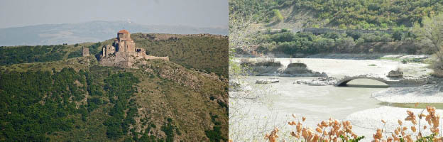
Monuments Svetitskhoveli Cathedral (11th century, see photo) and Jvari Monastery (6th century) in Mtskheta are amongst the most significant monuments of Georgian Christian architecture, and are historically significant in the development of medieval architecture throughout the Caucasus. Of special significance are early inscriptions, which form a valuable reference in the study of the origins of the early Georgian alphabet. In the outskirts of Mtskheta are the ruins of Armaztsikhe fortress (3rd century BC), the Armaztsikhe acropolis (dating to the late 1st millennium BC), remains of a "Pompey's bridge" (according to legends built by Roman legionnaires of Pompey the Great in 1st century BC), the fragmentary remains of a royal palace (1st–3rd century AD), a nearby tomb of the 1st century AD, a small church of the 4th century, the Samtavro Monastery (11th century), and the fortress of Bebris Tsikhe (14th century). The Institute of Archaeology, and the garden of Mikheil Mamulashvili are also worthy of note
Nine Dragon Heads 2012 Nomadic Party
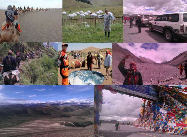
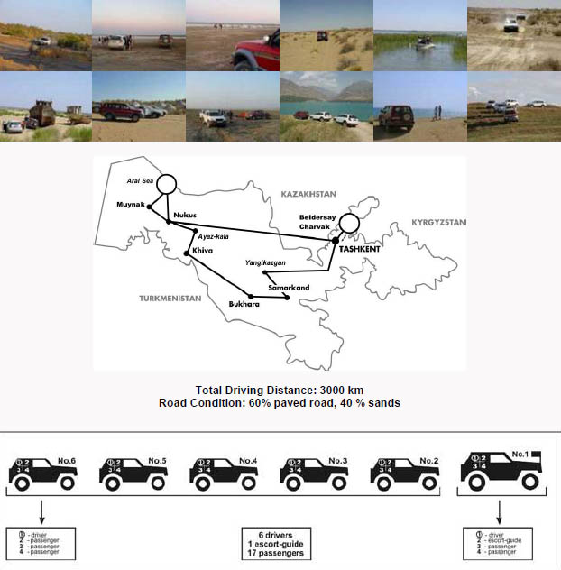
JEEP Safari One of the most exciting destinations
travel along the tracks of the Great Silk Road caravans
You will drive across the boundless deserts, immense steppes, little oases, beautiful mountain ranges, the dried bottom of the Aral Sea, the plateau Ustyurt, local villages and national settlements. The route you are going to cover was carefully researched. Our professional and experienced drivers will assist you in your journey.
Besides, you will visit the pearls of Uzbekistan – ancient cities Samarkand, Bukhara, Khiva, Ayazkala, Shakhrisabz, Nukus, Moynaq, Aral Sea included in UNESCO World Heritage list.
The vehicle offered for this journey is comfortable off-road vehicles and crossovers (nine vehicles). The leading car is supplied by GPS navigation system. In 10days you will cover the route of hundreds kilometers from the modern capital Tashkent to the shore of the Aral Sea.
You will be escorted by professional local guides throughout the entire tour. During your journey you will stay in quality hotels, as well as in traditional yurt camps. Besides, you will be provided with necessary camping equipment for certain part of your itinerary. This tour is designed for travelers who seek for discoveries and adventures. Explore the vast area of Uzbekistan and marvel its beauty! Come and enjoy unforgettable and unique journey of a lifetime!
|
Details Schedules |
|
|
19th. September |
|
|
11: 00 ~13:00 Conference at Istanbul Modern |
|
|
Day 1. |
Tashkent (Uzbekistan) |
|
20th |
The tour is planned to start from the noon in Tashkent International |
|
Airport, where you will be met by our guide and taken to the hotel for accommodation. After the group is collected in the hotel, evening sightseeing tour -take place in Tashkent. |
|
|
Orientation & First dinner together in local restaurant. |
|
|
Overnight in Tashkent |
|
|
Hotel Uzbekistan ★★★★ |
|
|
45, Мusakhanov str.,Tashkent, Uzbekistan, 700047 |
|
|
Tel : (+998 71) 113-1111, 113-1012, 113-1113 |
|
|
Day 2. |
Tashkent- Yangikazgan (Uzbekistan) |
|
21st |
Breakfast at hotel. |
|
Morning drive to Yangikazgan via mountain area – Forish. |
|
|
Stops en route for observing the surrounding area. |
|
|
Observing Aydarkul Lake. Picnic lunch at the lake upon arrival. |
|
|
Further drive via desert to Yurt camp for accommodation. Camel riding. |
|
|
Dinner in steppe with the camp fire Akyn singings afterwards. |
|
|
Overnight in Yurt |
|
|
|
|
|
Day 3. |
Yangikazgan –Samarkend (Uzbekistan) |
|
22nd |
After breakfast drive to Samarkand (185 km) with short visit to the desert Salt Lakes |
|
Lunch upon arrival in Samarkand local restaurant. |
|
|
Accommodation in hotel. |
|
|
Sightseeing in Samarkand. |
|
|
Dinner at local restaurant. |
|
|
Overnight in the hotel. |
|
|
Malika Classic B&B/ Kamila Hotel B&B |
|
|
Day 4. |
Samarkend –Bukhara (Uzbekistan) |
|
23rd |
Breakfast at hotel. |
|
Morning drive to Bukhara via Urgut village (short visit to local bazzar on Sat and Sun), |
|
|
Kitab Pass and Shakhrisabz city. |
|
|
En route sightseeing tour in Shakhrisabz. Lunch at local family in Shakhrisabz. |
|
|
Accommodation in hotel upon arrival in Bukhara. Dinner at local restaurant with folk show. |
|
|
Overnight in Bukhara. |
|
|
Hotel Minor ★★★★ / Hotel Asl ★★★ |
|
|
Day 5. |
Bukhara (Uzbekistan) |
|
24th |
After breakfast, sightseeing tour in Bukhara. |
|
After lunch Visit to Chor Bakr village. |
|
|
Observing Summer residence of Emir of Bukhara Sitorai-Mohi-Hosa. |
|
|
Dinner and overnight in Bukhara |
|
|
Culture Survey: Visit Samani dynasty mausoleum, Arc Fortress, Kalon ensemble…etc |
|
|
Lunch & Dinner at local restaurants. |
|
|
Overnight at hotel in Bukhara |
|
|
Hotel Minor ★★★★ / Hotel Asl ★★★ |
|
|
Day 6. |
Bukhara -Khiva (Uzbekistan) |
|
25th |
Breakfast at hotel. |
|
Drive to Khiva via desert (530km). |
|
|
Stops en route for sightseeing, observing the surrounding area and taking photos, |
|
|
in particular you will have an opportunity to see 2 desert Lakes. |
|
|
Lunch en route at road café. Upon arrival accommodation in hotel and dinner. |
|
|
Overnight in Khiva. |
|
|
Khiva Madrassa ★★★ / Arkonchi ★★ |
|
|
Day 7. |
Khiva-Ayaz Kala(Republic of Karakalpakstan) |
|
26th |
Sightseeing in Khiva. Lunch at local restaurant. |
|
Short visit to local village for acquaintance with local village life. |
|
|
After lunch Drive to Ayaz Kala |
|
|
Dinner and overnight in Yurt / Suzanne Bartos’s 60th Birthday Party |
|
|
Day 8. |
Ayaz Kala – Nukus (Republic of Karakalpakstan) |
|
27th |
After breakfast, Excursion of Ayazkala - series of three fortresses |
|
Picnic lunch at Yurt camp. / Further drive to Nukus. |
|
|
Visit to State Art Museum named after Igor Savitsky. |
|
|
Dinner and overnight in Nukus. |
|
|
Jipek Joli B&B |
|
|
Day 9. |
Nukus -Aral Sea (Republic of Karakalpakstan) |
|
28th |
After breakfast drive in the direction of Aral Sea |
|
Lunch en route in Kungrad./ Upon arrival setting up a camp on the Plateau Ustyurt. Preparing dinner on fire / Dinner round the fire under the stellar sky. Overnight in Tent |
|
|
Day10. |
Aral Sea – Moynaq (Republic of Karakalpakstan) |
|
29th |
After breakfast observing uninhabited scenery in the area of Aral Sea. |
|
Drive to Moynaq / Lunch upon arrival in Moynaq |
|
|
13:00~16:00 Outdoor Exhibition ‘Boat to boat’ at Graveyard of Ship |
|
|
16:00 Drive to Nukus Airport |
|
|
20:55 Flight to Tashkent (by HY-1008 ) |
|
|
23:10 Arrival Tashkent Airport |
|
|
Pick up Baggage / Go through the international Terminal |
|
|
Day 11. |
Departure procedure Tashkent – Tbilisi (Georgia) |
|
30th |
06:30 Flight to Tbilisi ( by VV-484 / via Kiev ) |
|
17:10 Arrival at Tbilisi / Hotel Room Arragement Hotel VIP |
|
|
Dinner at local restaurant / Sim Jae-Bun’s 50th Birthday Party |
|
|
October |
|
|
Day12. |
Tbilisi -Mtsketha (Georgia) |
|
1st |
Culture Survey-UNESCO Heritage (Mtskheta, Tbilisi ) |
|
Lunch/ Dinner at Restaurant |
|
|
Day13. |
Breakfast at the hotel. (Tbilisi. Georgia) |
|
2nd |
10:00 Set Up Exhibition |
|
Lunch – Self / Dinner at Local Restaurant |
|
|
Bruce Allan’s Birthday Party ( at Bruce Studio ) |
|
|
Day14. |
Breakfast at the hotel. (Tbilisi. Georgia) |
|
3rd |
10:00 Set Up Exhibition |
|
Lunch – Self Expenses |
|
|
19:00 Dinner at Local Restaurant |
|
|
Day15. |
Breakfast at the hotel. (Tbilisi. Georgia) |
|
4th |
10:00 Set Up Exhibition |
|
Lunch – Self Expenses |
|
|
19:00 Dinner at Local Restaurant |
|
|
Day16. |
Breakfast at the hotel. (Tbilisi. Georgia) |
|
5th |
18:00 Opening at National Museum |
|
Dinner at Local Restaurant |
|
|
Day17. |
Breakfast at the hotel. (Tbilisi. Georgia) |
|
6th |
11:00 Presentation ( National Museum ) |
|
Farewell Party ( announce at Tbilisi ) |
|
|
Day18. |
Breakfast at the hotel. (Tbilisi. Georgia) |
|
7th |
Check out / Individual Departure |